© Geoff Radcliffe 2011
Welsh 3000s July 2011
If you are reasonably fit and are able to navigate in the hills, the Welsh 3000s may be a suitable challenge for you. To ensure success a reasonable amount of planning may be necessary. My tips are:
- Travel light but take the essentials.
- Pick a time when the weather is fine and settled, there is no mist on the summits and it is not too windy.
- Learn the route by studying maps, viewing the route in Google Earth and walking parts of it.
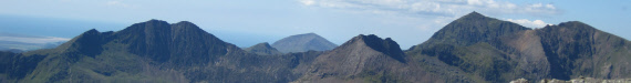
- Get the exact location of each summit and find out what the summits look like. See the photos on this site.
- Know your capabilities. Be prepared to abandon the walk if the weather turns nasty, if it is taking you too long, you become too tired or injured to continue. So plan your escape routes for each section.
- Drink plenty of water before setting off.
- Set off early. If you set off in the dark and get lost you can wait until it gets light. If you get lost in the dark of the evening, you may have to wait a long time before it gets light.
- I had my support supply me with food and water at convenient places where the route met the road. If you have no support, hide food and water along the route before setting off.
Equipment
Take lightweight gear. I found the following useful:
- Lightweight sack, lightweight walking boots, ankle gaiters, walking poles.
- High-wicking base layer, a mid-layer (such as a fleece), a hat or head scarf.
- Good quality socks plus a spare pair.
- Waterproofs.
- Compass, maps, schedule, GPS with spare batteries, whistle, torch with spare batteries, space blanket, money, mobile phone, sun-glasses, sun screen.
- Water bottle and food.
In addition, I took a digital camera to make a record of my journey. This had the added advantage of recording the time of day for each photograph.
Choice of Route
I found that the choice of route was key to my success. The choices I made were:
- To descend from Tryfan by its West Gully rather than by Bwlch Tryfan to the south.
- To ascend Pen yr Ole Wen directly from Ogwen Cottage rather than from Glan Dena which is further and can be boggy.
- To contour round the hillside south of Carnedd Llewelyn to get to Yr Elen rather than climbing Carnedd Llewelyn first and descending back down to Yr Elen.
The Tricky Bits
The following parts of the route I took that I found either tricky to navigate or awkward:
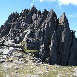
- The Crib Goch ridge particularly the pinnacles area.
- Locating the actual summit of Crib Goch.
- Finding the best descent from the north ridge of Crib Goch into Cwm Glas Bach.
- Locating the actual summit of Glyder Fawr. It is the one to the left of the main path,
- Reaching the summit of Glyder Fach. The easiest approach seemed to be to go round to the right (east) of the summit before ascending it.
- The ascent of Tryfan from Bwlch Tryfan. It is best to go round to the left of the south peak.
- Locating the actual summits of the Carnedd peaks with the exception of Foel Fras which is marked by a trig point.
- The descent from Foel Fras to Llyn Anafon. The path is faint and boggy. This could be difficult in the dark, so plan for an alternative such as the longer route over Drum.